SEO title: Monmouth County NJ Land Use and Environmental Review 2026: CAFRA, Wetlands, Tidelands, and Fort Monmouth Redevelopment
Meta description: A technical guide for developers on CAFRA, coastal wetlands, tidelands instruments, freshwater wetlands, and Fort Monmouth redevelopment in Monmouth County, New Jersey.
Monmouth County development does not follow a SEQRA or CEQR review pathway. Those are New York environmental review frameworks. A project in Monmouth County proceeds through NJDEP requirements, local municipal land-use authority, and any applicable federal approvals.
For developers, the central question is not whether a site is near the coast. It is which regulated resources overlap the parcel, which permit pathway applies, and whether the proposed use is consistent with the site’s environmental restrictions.
This matters in Long Branch, Asbury Park, Neptune, Red Bank, the Bayshore communities, and the former Fort Monmouth property in Eatontown, Oceanport, and Tinton Falls.
The Monmouth County review framework
New Jersey’s coastal zone includes tidal and non-tidal waters, waterfront areas, wetlands, developed urban centers, industrial properties, and inland areas connected to coastal resources. NJDEP states that most construction in the coastal zone requires an authorization before work begins. The agency’s Coastal Zone permitting guidance identifies CAFRA, the Waterfront Development Law, the Wetlands Act of 1970, and the Coastal Zone Management Rules as the primary authorities.
A typical development review may involve:
- Local zoning, site plan, subdivision, and planning board approvals
- NJDEP CAFRA authorization
- Waterfront Development authorization
- Coastal wetlands review
- Freshwater wetlands authorization under the Freshwater Wetlands Protection Act
- Tidelands grants, leases, licenses, or other instruments
- NJDEP Site Remediation Program coordination
- An NJDEP Licensed Site Remediation Professional, or LSRP, for privately managed remediation
- Federal wetlands, floodplain, endangered species, or historic resource review where applicable
The first step is a parcel-specific constraint map. Do not begin with a generic permit list.
CAFRA zones and coastal planning areas
The Coastal Area Facility Review Act, or CAFRA, applies to regulated development in New Jersey’s coastal area. NJDEP uses mapped coastal planning areas, centers, cores, and nodes to evaluate a project’s location and intensity.
The same use may receive different treatment depending on whether the parcel sits in a coastal metropolitan area, suburban planning area, fringe area, rural area, environmentally sensitive area, or a mapped center.
This classification affects the review of:
- Building intensity
- Non-porous or impervious cover
- Vegetative cover
- Development location
- Public access
- Coastal resource impacts
- Compatibility with surrounding land uses
Monmouth County’s coastal communities are not regulated as one uniform district. Long Branch, Asbury Park, Neptune, Red Bank, and Bayshore municipalities each contain different combinations of developed land, tidal waterways, wetlands, flood-prone areas, and mapped centers.
A developer should confirm the applicable planning area through NJDEP’s coastal mapping tools before finalizing a site plan. NJDEP provides an online coastal mapping tool for identifying coastal resources and other regulated features.

CAFRA applications, EIS requirements, and site plans
A CAFRA Individual Permit is generally required when a project cannot qualify for a permit-by-rule, general permit-by-certification, or general permit.
NJDEP’s Individual Permit Application Checklist should control the submission. The application may require:
- Completed application forms and fees
- Public notice documentation
- An Environmental Impact Statement
- Existing conditions plans
- A detailed proposed development plan
- Topographic information
- Wetland, waterway, and coastal resource mapping
- Impervious and vegetative cover calculations
- Public access documentation
- Alternatives and mitigation information
- Technical reports supporting the compliance statement
Under N.J.A.C. 7:7-23.6, the EIS should explain the proposed activity, the site and regional setting, environmental resources, construction impacts, operational impacts, mitigation, and compliance with applicable coastal policies.
The plan set should show more than property lines and building footprints. NJDEP needs to understand how the proposed work changes the site.
Existing conditions plans should identify:
- Property boundaries and easements
- Existing buildings, pavement, utilities, bulkheads, docks, and access routes
- Topography and spot elevations
- Wetlands, waterways, flood-prone areas, wooded areas, and vegetation
- Existing public access points
- Tidal features and shoreline conditions
- Existing impervious and vegetated areas
Proposed plans should show:
- Building footprints and paved areas
- Grading and elevation changes
- Construction limits
- Utility work
- Proposed access routes
- Landscape and restoration areas
- Public access improvements or restrictions
- Impervious cover and vegetative cover calculations
The application must also address the applicable standards under N.J.A.C. 7:7, including the rules for special areas, general water areas, non-porous cover, vegetative cover, location, use, and resource protection.
Do not assume that a standard impervious cover percentage applies to every Monmouth County parcel. The controlling requirements depend on the mapped planning area, center or node, resource constraints, use, and permit type.
The same principle applies to runoff and drainage design. The application must demonstrate compliance with the applicable NJDEP requirements without treating a generic drainage narrative as a substitute for project-specific calculations.
Waterfront Development Law and tidelands instruments
The Waterfront Development Law regulates work in and near tidal waterways. Activities at or below the mean high water line often require a Waterfront Development authorization. Natural waterways typically receive more intensive review than man-made lagoons or already authorized waterfront facilities.
Potentially regulated work includes:
- Bulkheads and shoreline structures
- Piers, docks, and boat lifts
- Fill placement
- Dredging
- Utility crossings
- Shoreline stabilization
- Upland development that affects waterfront resources
Tidelands review is a separate title and regulatory issue. Land may be subject to the State’s tidelands interest if it is now or was formerly flowed by the tide. A parcel may require a tidelands grant, lease, license, easement, or other instrument. In other cases, the developer may need a statement or determination addressing the State’s interest.
A title commitment alone may not resolve this issue. The development team should compare the survey, deed history, historic shoreline, NJDEP mapping, and any existing tidelands instruments.
NJDEP’s Tidelands Management program should be reviewed early, especially for parcels along the Shrewsbury River, Navesink River, Raritan Bay, tidal creeks, and the Bayshore.
Coastal and freshwater wetlands
The Wetlands Act of 1970 protects coastal wetlands. Freshwater wetlands are regulated primarily under the Freshwater Wetlands Protection Act and N.J.A.C. 7:7A.
A single Monmouth County project may involve both systems. For example, a redevelopment parcel may contain freshwater wetlands inland, a tidal creek along one boundary, and a proposed utility connection crossing a regulated transition area.
The review should distinguish:
- Coastal wetlands
- Freshwater wetlands
- Wetland transition areas
- Tidal waterways
- Riparian areas
- Flood hazard areas
- Upland areas affected by access, grading, or utility work
A wetlands delineation should be completed before the civil plan is fixed. Moving a building footprint after the design team has committed to a wetland impact area can affect density, parking, access, utility routing, and project economics.
For a private brownfield redevelopment project, the environmental consultant and NJDEP LSRP should coordinate the site investigation, remedial strategy, wetlands constraints, soil management, and construction sequencing. The goal is one coordinated path to approval, not separate reports that contradict one another.
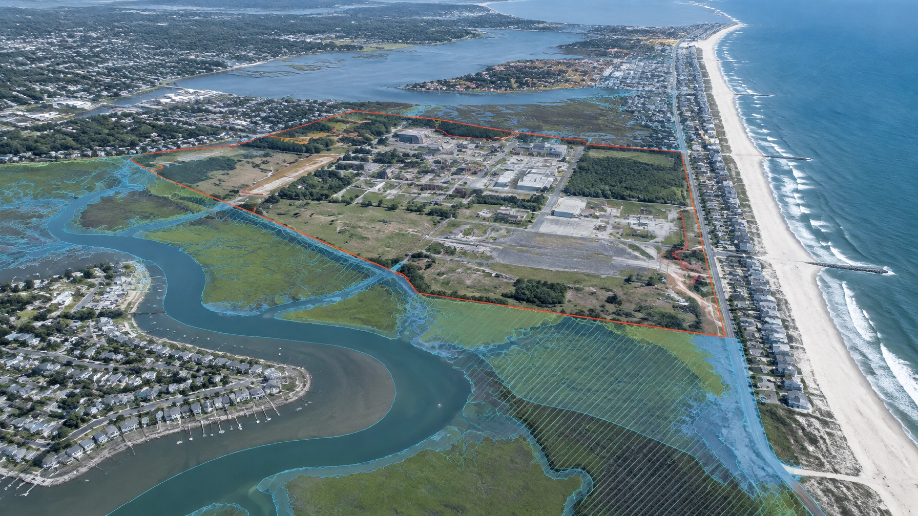
Fort Monmouth redevelopment: what developers must verify
Fort Monmouth is a specific redevelopment context. The U.S. Army is the lead federal agency for the installation’s CERCLA program, and NJDEP acts as the state support agency. The Army’s 2017 Record of Decision for seven Fort Monmouth landfill sites documents that relationship.
The ROD covers FTMM-03, FTMM-04, FTMM-05, FTMM-12, FTMM-14, FTMM-18, and FTMM-25 in Oceanport, Eatontown, and Tinton Falls.
The ROD found that risks were acceptable for the intended future use as passive open space. That finding did not mean the landfill areas were unrestricted development parcels.
The selected remedy included:
- A vegetated soil cover
- Land-use controls
- A Land Use Control Implementation Plan
- Cover inspections, maintenance, monitoring, and reporting
- Restrictions on residential land use
- Groundwater-use restrictions at FTMM-05 and FTMM-18
- Classification Exception Areas for specified groundwater restrictions
- Deed notices or equivalent recorded controls upon transfer
The ROD states that the Army retains ultimate responsibility for remedy integrity, while a new property owner must comply with the land-use controls after transfer.

For a developer acquiring or redeveloping a former installation parcel, “no further action” cannot be treated as a blanket release from all environmental obligations. The relevant question is what the decision document, deed notice, land-use control implementation plan, groundwater restrictions, and current NJDEP records allow at the specific parcel.
Before closing or construction, verify:
- The current parcel boundary and property history
- The applicable Fort Monmouth decision documents
- Recorded deed notices and restrictions
- Land-use control maps
- Groundwater restrictions and CEAs
- Cap inspection and maintenance obligations
- Excavation and utility requirements
- NJDEP concurrence, approvals, or open remediation obligations
- Whether the proposed use matches the approved land-use assumption
The U.S. Army Corps of Engineers Fort Monmouth program and Fort Monmouth site records repository should be reviewed for current documentation. Status can change as remedies, transfers, monitoring, and land-use controls are updated.
What developers should do before committing capital
For Monmouth County land, the practical sequence is straightforward:
- Map CAFRA, wetlands, tidal, flood hazard, and municipal constraints.
- Confirm whether the site needs CAFRA, Waterfront Development, wetlands, or tidelands authorization.
- Review existing deeds, surveys, title exceptions, and recorded environmental controls.
- Complete environmental due diligence for developers in New Jersey before acquisition.
- Coordinate the NJDEP LSRP, civil engineer, wetlands specialist, land-use attorney, and municipal professionals.
- Prepare the EIS, compliance statement, site plans, and technical exhibits as one coordinated package.
- Verify the current status of all agency decisions before relying on an older approval or ROD.
- Build construction controls and long-term obligations into the budget and schedule.
Envicon supports this work through compliance and permitting, brownfield redevelopment, lender due diligence, and construction oversight. Our team works directly with developers, attorneys, engineers, municipalities, NJDEP, and field contractors.
The takeaway
Monmouth County permitting is not a single approval. It is a coordinated review of land use, coastal resources, wetlands, tidal interests, remediation obligations, and future site operations.
CAFRA determines more than whether a project is near the shore. Tidelands instruments can affect title. Wetlands can reshape the site plan. Fort Monmouth land-use controls can limit excavation and future use even where a CERCLA ROD identifies no unacceptable risk for the approved land-use scenario.
The right environmental consultant brings those issues together before they become closing conditions, redesigns, or construction delays.
Start with a clear path
- Use Envicon’s proprietary project risk screener
- Use the proprietary cost estimator
- Connect with Envicon on LinkedIn

Leave a Reply